
Where is the Nicoya Peninsula?
In northwest Costa Rica, across the Gulf of Nicoya from Puntarenas. Santa Teresa and Malpaís sit at its southern tip (the box on the map below), and the Puntarenas–Paquera ferry is the dotted line across the gulf.
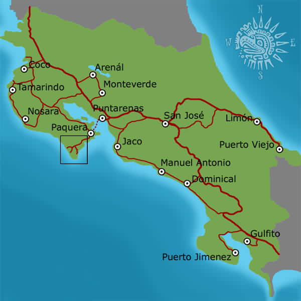
The peninsula is about 120 km (75 miles) long. Its north, from Tamarindo and Nosara down to Coyote, is Guanacaste; the south, below the Río Bongo just north of Manzanillo, is Puntarenas. There are two coasts: the open Pacific (surf, currents, sunsets) and the calm Gulf of Nicoya (bays and islands). Our Nicoya Peninsula guide describes each area.
Southern tip driving map
The one paved road in comes from Paquera through Tambor to Cóbano, then splits: down to Montezuma on the Gulf side, or over the hills to the Playa Carmen crossroads, between Malpaís and Santa Teresa, on the Pacific side.
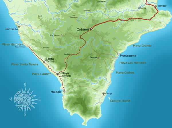
For the route from San José and Liberia, see our driving map; for the hotels and beaches in town, the Santa Teresa town map.
Every beach and town, south to north
Drive times are from the Playa Carmen crossroads in Santa Teresa, in a normal car, in good conditions. Add time in the rainy season and at busy holiday weekends.
Santa Teresa & Malpaís
| Place | What it is | From Santa Teresa | Road |
|---|---|---|---|
| Playa Los Suecos (Playa Cuevas) | Snorkeling cove at the Cabo Blanco border, reached through the fishing port | About 15–20 min | Gravel or dirt. Narrow dirt track via the Malpaís port |
| Malpaís | Quiet fishing village, rocky coves and the Mar Azul tide pools | About 15 min | Gravel or dirt. Dirt side roads off the main strip |
| Playa Carmen | The crossroads (El Cruce): banks, ATMs, pharmacy, supermarkets | 0 (the reference point) | Mostly paved, some dirt. Paved in from Cóbano to within a few km of the coast; the town road is dirt and gravel |
| Santa Teresa | The main strip: hotels, restaurants, yoga, surf lessons | In town | Gravel or dirt. Mostly gravel and dirt, dusty in the dry season, paving in progress |
| Playa Hermosa | Long, quiet beach; beginner surf lessons | 10–15 min | Gravel or dirt |
| Manzanillo | End of the coast road: sunsets, reef lagoon at low tide | About 20 min | Gravel or dirt |
Cabo Blanco & Montezuma
| Place | What it is | From Santa Teresa | Road |
|---|---|---|---|
| Cabo Blanco Absolute Nature Reserve | Costa Rica's first protected area; entrance south of Cabuya only | About 1 h | Mostly paved, some dirt. Via Cóbano and Montezuma. The direct Malpaís–Cabuya track is 4x4, dry season only |
| Cabuya | Fishing village; cemetery island you can walk to at low tide | About 1 h | Mostly paved, some dirt. Via Cóbano and Montezuma |
| Montezuma | Walkable bohemian village, waterfalls, Isla Tortuga boats | 35–40 min | Paved. Paved from Cóbano; steep descent into the village |
| Playa Grande (Montezuma) | Long beach north of Montezuma | 35–40 min + a walk | On foot from the road. About 45 minutes' beach and jungle walk from Montezuma |
| Cóbano | Services: the only gas stations, banks, clinic, Cóbano airport (ACO) | 20–30 min | Mostly paved, some dirt |
Gulf side
| Place | What it is | From Santa Teresa | Road |
|---|---|---|---|
| Tambor (Bahía Ballena) | Wide, calm bay; all-inclusive and golf | About 45 min | Paved |
| Pochote and Playa Muertos | Hamlet east of Tambor; a short boat ride to calm, white-sand Playa Muertos | 45–60 min | Mostly paved, some dirt. Flat dirt spur off the paved road |
| Curú Wildlife Refuge | Private refuge: flat trails, monkeys, a calm swimming bay | About 1 h–1 h 10 | Mostly paved, some dirt. Paved to the gate, then 2 km of farm track |
| Isla Tortuga | White-sand island; snorkeling and calm, clear water | Full-day boat tour (about 7 h) | Boat only. Tours pick up in Santa Teresa, Malpaís, Montezuma, Cabuya or Tambor |
| Paquera | Ferry dock for Puntarenas; groceries, ATM, gas | About 1 h 15 | Paved |
| Playa Naranjo | The second ferry dock for Puntarenas | About 1 h 30 | Paved |
Coyote to Islita
| Place | What it is | From Santa Teresa | Road |
|---|---|---|---|
| Playa Coyote | Remote beach and village; calm cove at Punta Coyote | About 1 h 20–1 h 30 (dry season) | 4x4, river crossings, dry season only. Coastal track with the Arío and Bongo fords, Jan–Apr only; year-round via Paquera and Jicaral, about 3–3½ h |
| Playa San Miguel | Empty grey-sand beach with holiday homes; strong rips | About 1 h 30 (dry season) | 4x4, river crossings, dry season only |
| Playa Bejuco | Mangrove-ringed beach with low-tide pools | About 1 h 40 (dry season) | 4x4, river crossings, dry season only |
| Punta Islita | Horseshoe bay below Hotel Punta Islita | About 2 h dry season, 3 h rainy season | Gravel or dirt. Coastal 4x4 track with river crossings in the dry season, around by road the rest of the year; the last 15 km is bumpy dirt, 4WD needed |
| Playa Camaronal | Turtle-nesting refuge; not a swimming beach | About 4 h (paved loop) | Mostly paved, some dirt. Via Carrillo and the Río Ora bridge |
Sámara & Carrillo
| Place | What it is | From Santa Teresa | Road |
|---|---|---|---|
| Playa Carrillo | Palm-lined crescent, calm and swimmable | 4–4½ h | Paved. Paved loop via Paquera, Jicaral and Nicoya |
| Sámara | Walkable Tico beach town on a reef-protected bay | 4–4½ h | Paved. Paved loop; the coastal route (2½–3½ h) is dry-season 4x4 only |
| Playa Barrigona | Wild white-sand beach north of Sámara | Sámara + 15–30 min | Gravel or dirt. Dirt road north of Sámara; 4x4 recommended |
Nosara & Ostional
| Place | What it is | From Santa Teresa | Road |
|---|---|---|---|
| Playa Garza | Reef-protected fishing-village bay | About 4½ h | Mostly paved, some dirt. Gravel on the last stretch |
| Nosara: Playa Guiones | Surf and yoga beach with no beachfront building | 4½–5 h | Mostly paved, some dirt. Paved to Barco Quebrado, then a potholed access road; 4x4 advised May–Nov |
| Nosara: Playa Pelada | Rocky cove with tide pools and a blowhole | 4½–5 h | Mostly paved, some dirt |
| Ostional | Olive ridley turtle arribadas; guide required | About 5 h | Mostly paved, some dirt. Bridged, but the road can be impassable after heavy rain |
Northern peninsula
| Place | What it is | From Santa Teresa | Road |
|---|---|---|---|
| Nicoya town | The peninsula's hub: hospital, colonial church, Blue Zone villages nearby | 3–3½ h | Paved. Via Paquera, Jicaral and Route 21 |
| Barra Honda National Park | Limestone caves; guided descent, age 12 and up | 3–3½ h | Paved |
Which roads are paved, and where are the river crossings?
- Paved: Paquera to Cóbano and Montezuma, and the loop north via Playa Naranjo, Jicaral and Route 21 to Nicoya, Sámara and the Nosara turnoff. It's the only year-round road between the southern and northern halves. Google Maps now labels part of the Paquera–Cóbano road Route 21; older maps say 160.
- Dirt and gravel: the last few kilometers into Santa Teresa and Malpaís and the town road itself (dusty in the dry season, rutted in the rainy season, with paving in progress), and the access roads to Nosara's beaches.
- River crossings: the coastal track north of Manzanillo to Coyote, San Miguel, Islita and Sámara fords rivers with no bridges. It's for high-clearance 4x4s in the dry season (roughly January to April) only. The rainy season runs May to early December and is heaviest from mid-September to mid-November; never drive into a river in flood, and note that rental insurance doesn't cover water damage.
Insider tip: if your GPS offers a "shortcut" across the middle of the peninsula, ignore it. Those routes are farm tracks with river crossings. Stick to the paved roads through Paquera, Jicaral and Nicoya, and fill up in Cóbano or Paquera: there's no gas station in Santa Teresa.
How far is Santa Teresa from the airports and other towns?
| From Santa Teresa to | Time | Road |
|---|---|---|
| Liberia airport (LIR) | 4½–5½ hours | Paved via Nicoya, Jicaral and Paquera; no ferry |
| San José airport (SJO) | 5½–6 hours with the ferry; 6–6½ hours by road | Paved; Puntarenas–Paquera ferry or around via the La Amistad bridge |
| Tamarindo | 4½–5 hours | Paved via Nicoya |
| Monteverde | 5–5½ hours | Paved, with the ferry; curvy and steep near Monteverde |
| La Fortuna (Arenal) | 6–7 hours | Paved, with the ferry or around by road |
| Jacó | About 2½–3 hours door to door by water taxi via Montezuma; 4½–5 hours by road and ferry | Boat across the gulf, then the road from Montezuma |
Short on time? Fly from San José airport (SJO) to Cóbano airport (ACO) in 30 to 35 minutes; Santa Teresa is 25 to 30 minutes from the airstrip. See getting to Santa Teresa.
Frequently asked questions
Where is the Nicoya Peninsula on a map of Costa Rica?
In the northwest, on the Pacific coast, west of Puntarenas across the Gulf of Nicoya. Liberia airport (LIR) lies just north of it; Santa Teresa and Malpaís are at its southern tip, facing the Pacific.
How long does it take to drive the length of the Nicoya Peninsula?
From Santa Teresa at the southern tip to Nosara is 4½ to 5 hours on the paved road via Paquera, Jicaral and Nicoya, and Liberia airport is 4½ to 5½ hours. In the dry season the coastal track via Coyote is shorter on the map but slow, with river crossings.
Can you drive along the coast of the Nicoya Peninsula?
Partly. From Manzanillo north to Coyote, San Miguel and Sámara, the coast road is a dirt track. Between Manzanillo and Coyote it fords the Arío, Caño Seco and Bongo rivers with no bridges; north of Coyote the rivers are bridged, but the road is rough. It's a high-clearance 4x4 route in the dry season only (roughly January to April), and rental insurance doesn't cover water damage. The rest of the year, use the paved loop inland.
How far is Montezuma from Santa Teresa?
About 35 to 40 minutes by car via Cóbano, on a paved road with a steep descent into Montezuma. Tambor is about 45 minutes and the Cabo Blanco reserve about an hour. See the driving map.
How far is Nosara from Santa Teresa?
4½ to 5 hours by the paved loop via Paquera, Jicaral and Nicoya. The coastal route is shorter but has river crossings and is only passable by 4x4 in the dry season. Read the Nosara guide.
Is there a map of Santa Teresa's beaches and hotels?
Yes: our Santa Teresa and Malpaís town map shows the beaches, the Playa Carmen crossroads and the hotels from Malpaís to Manzanillo.